
|
WHITEHALL ROMAN VILLA AND LANDSCAPE PROJECT
|
|
The site was finally reinstated (i.e. buried) on 18th September 2012.
The story so far: a brief introduction to the site and the project
(updated in September 2012)
This is a brief introduction to Whitehall Villa: you can find more information and more photographs about almost every aspect elsewhere on this web site using the links in the column on the left. To follow up our finds, go to the Material Culture area of the site.
You can also view several videos. The best short intoruduction is the 2009 video.
The site
Whitehall Farm lies about 70 miles North of London, on the A5 trunk road. The A5 closely follows the route of the Roman Watling Street which ran from London to Holyhead in Wales. The nearest Roman towns on Watling Street were Lactodorum (Towcester) about 8 miles south, and Bannaventa (Whilton Lodge) about 3 miles to the north. The nearest village is Nether Heyford to the East. This area of West Northamptonshire is rich in Romano-British archaeology.
The villa site itself stands on a hillside with a beautiful panoramic view eastwards over the upper valley of the River Nene.
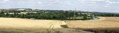
View to the East from the North end of the site
This is a classic English midlands agricultural landscape, with mixed arable and livestock farming in fields marked by ancient hedgerows. In the foreground, at the bottom of the hill, runs the late-18th century Grand Union canal. In the distance are glimpses of the M1 motorway and Northampton. Between the villa site and the A5 runs the main west coast railway line from London to Birmingham and points North.
The main archaeological site includes (in roughly historical order) two roundhouses, a proto-villa, a late romano-british villa, two bath houses, all, except the proto-villa, within a ditch and bank enclosure of about 2 hectares. This site was continuously occupied for at least 500 years. Elsewhere on the farm we have excavated a 7th century saxon cemetery.
CLICK here for an aerial photo of the site showing major features - this will open in another browser window
(This aerial photo is now looking a bit dated: but it shows the site at it''s greatest uncovered extent, and the information is still valid. The site has changed a lot in appearance a - the villa range, courtyard and bath house 1 have now been reburied to preserve the remains; and bath house 2 has now been excavated much further.)
The geophysical survey revealed an early 2nd century AD mixed farming landscape based on stone round houses with accompanying rectangular enclosures and inland field system.
The villa and bath houses were built and re-built during the early 3rd to late 4th centuries AD. The villa was a typical, medium sized, two-storey corridor villa with a large wing at the western end - there was almost certainly an east wing too, but we have not found conclusive evidence of it yet. Most of the foundations of the main villa range have been robbed out.
The two roundhouses we have found stood at each end of the villa - that is, the villa was built between them. The northern round house has been completely robbed out, and some of its stones were probably re-used in the bath house. Of the southern round house we found a substantial stretch of foundation and pottery dating to the 2nd century AD.
To the east of the villa is a large paved surface surrounded by a gravel courtyard. This is where the burned-out post holes of the post-roman timber-framed building have been identified. The site has produced just one burial so far, found underneath the level of the courtyard.
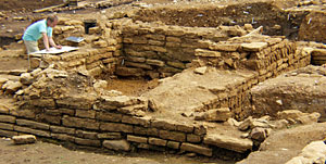
Bath house 1 (the first to be excavated, but, confusingly, the second bath house built on the site) still has standing walls up to eight courses high, and was a very impressive sight with its stoke house and hypocaust still clearly visible. It was re-modelled several times (possibly becoming a dwelling at a late stage) and poses many puzzles. Why is it so large? Why are the stones at the bottom end so massive? How was the water supply managed? But we know quite a lot about the way it was drained and cleansed by water from a spring.
One room of the bath house had a "sealed context" - an area of continuously wet soil containing a huge number of environmental finds preserved by the water including seeds, pollen and over 5,000 wild animal bones. We have also found brooches, rings, many pot sherds and fragments of 20 to 30 glass vessels (mainly from the Rhineland), including pieces of a 4th century conical beaker engraved with the figure of a gladiator - a very rare find! There were also hundreds of pieces of late 3rd to early 4th century wood - Whitehall is one of only a handful of sites in the UK to have a collection of roman wood. The finds and data from "room 3b" of our bath house could prove of national importance.
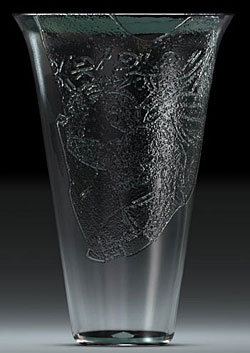
Time Team's virtual reconstruction of our gladiator beaker
During the 2004 excavation we found evidence for another romano-british building to the East of the villa, further down the hill: in 2005 we found that it had a hypocaust and a range of rooms: the 2006 dig opened uo more of the "new" building, but at that stage it was still not clear what function it served. It is now understood to be the villa's first bath house (bath house 2, just to be confusing!) abandoned when it became impossible to keep properly drained - its materials were reused in building bath house 1.
Up to and including 2006, the site was run as an "open area excavation": it was been covered over with straw bales and plastic sheeting each winter, and the whole of it's area was been completely weeded and cleaned each year to allow new developments to be seen in the context of the site as a whole. (The exception is the proto-villa area in a field adjacent to the main site - this was closed at the end of the 2002). In 2006, the villa range was not weeded and cleaned; but the bath house was, so that a "virtual walkthrough" could be photographed.
In 2007 there was only a small-scale dig at Whitehall, and this was not concerned with the villa or bath house. After the 2007 season, the villa range area was returned to pasture, but the floor plan of the villa itself has been picked out using grass seed of a different colur and texture.
In 2008 the bath house was again weeded and cleaned so that final investigations could be carried out: it was reburied and the land returned to pasture after the 2009 season, and the Open Day at the end of that dig. The courtyard was returned to pasture at the same time.
In 2009, 2010, 2011 and 2012, the main focus of the dig was on bath house 2, which was fully excavated.
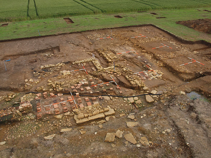
Bath house 2 at the end of the 2012 dig - looking East
In 2010 the site of the auxliary building (also known as the "proto-villa" - in the field next door) was revisted to check out the previous findings against our latest understanding of the whole site.
In 2012 we completed the excavation of bath house 2, and, indeed, of the whole villa site.
On 18th September 2012 the site was infilled and returned to pasture.
But the Whitehall story is not finished: the analysis and interpreation of the villa site will continue for some time yet, and we hope to investigate various other aspects of the Whitehall landscape including the "missing" roman cemetery. This website will be kept up to date with developments as they occur.
The project
The site was found in 1996 by metal detectorists - fieldwalking, geophysical surveys and preliminary excavations followed soon afterwards. The site has been the subject of a major annual excavation each year since 2000. The first three of these digs were training excavations providing archaeology students with structured field work experience to help them to qualify. Students from many UK universities attended: others travelled from the USA, Canada, Japan and Australia to take part. There has been more informal student involvement in the excavations in most years since.
But volunteers, mainly local, have always made up the bulk of the workforce: basic training is given in field archaeology skills and finds processing, and many volunteers have become experienced and skilled in many aspects of archaeological practice. The Director of Archaeology is Stephen Young, a Senior Lecturer at the University of Northampton.
The Whitehall Farm Roman Villa and Landscape Project is run by Stephen Young and by Nick Adams, the farmer who owns the site. It has been funded by grants from various local bodies, including the South Northamptonshire District Council, by donations, and by the proceeds of several Open Days held at the end of some of the annual digs. The Project has also benefitted from sponsorship in kind by several businesses and organisations. In 2008 the site became the subject of a Higher Level Environmental Stewardship agreement between Natural Engand and Nick Adams: one result is that interpretation boards were commissioned and installed.
In 2005 Whitehall villa was proud to be selected as one of only nine projects nationwide to be featured in the Time Team's "Big Roman Dig" TV series made for Channel 4 and broadcast in July. The daily 'weblog' reports written for C4 were also posted on this site with extra photos. They give you some of the flavour of the 2005 excavation. The excavation blog has continued ever since.
Whitehall villa is just one of many sites in the area being studied by CLASP (Community Landscape and Archaeology Survey Project) with which the Whitehall Project is closely associated. CLASP has its own website, including detailed reports of fieldwork.
We hope you enjoy finding out more about Whitehall Villa by exploring this site.
| © | Copyright of this web site, including all text and images (except where otherwise stated), belongs to The Whitehall Farm Roman Villa and Landscape Project. No part of this website may be reproduced in any form without the prior permission of the Project. |